TECHNOLOGY
Bridging the Gap Between Technology and the Industrial Market

Next-Generation Solutions with
State-of-the-Art Technology
Drone Equipment
In situations demanding urgency, there exists no leeway for rentals. This is why EDS maintains ownership of the equipment utilized in every project. From the DJI RTK 300 to the Elios 3, our equipment fleet encompasses a diverse array of drones across varying sizes, ensuring the seamless execution of tasks at hand.


Mobile Mapping & Geospatial Equipment
EDS utilizes cutting-edge technology to deliver precise and efficient data collection. The laser scanner is leveraged for both ground-based and drone-based mobile laser scanning. In addition to that, EDS employs a smart antenna & field controller, ensuring high-precision measurement of distances, angles, and elevations. These tools allow our team to provide accurate and efficient data from both the ground and air.


Local Data Hosting
EDS has local hosting capabilities, allowing all data from our team and clients to be securely stored and managed from our office without relying on the cloud. By maintaining our own infrastructure, we provide a stable and secure environment tailored to the specific needs of our clients and projects.
bringing designs to life
The Future of Engineering
with VR & AR
Virtual Reality
We harness the capabilities of the Meta Quest Pro to offer our clients a unique perspective on their projects. Our team has crafted immersive 3D models, accessible through virtual reality, enabling clients to envision their projects well before construction begins. This foresight not only guarantees a seamless preview but also ensures optimal operational and maintenance planning for projects.


Augmented Reality
Engineering Design Services employs the Microsoft HoloLens2 to integrate augmented reality in the field. This intrinsically safe tool allows our clients to visualize intricate 3D models directly within the operational environment. This approach allows our clients to identify and eliminate potential interferences that could delay construction.
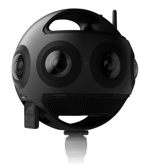
capturing every angle
Immersive 360° 3D Imaging
Engineering Design Services utilizes the insta360 TITAN 3D - 360 3D Camera. The TITAN contains eight micro four thirds sensors. These sensors maximize image quality, dynamic range, low-light performance, and color depth, raising the bar for the engineering performed for our clients.